Category Archives: Practical Information

CaminodeSantiagowebYou can find in this page all the information and materials that I’ve collected before leaving on my walk from Milan to Fisterra. You will be able to download documents and go through the links and the biblography I’ve found and prepare your own walk from Milan to the Atlantic Ocean, along the routes that lead to Santiago de Compostela. Buen Camino!

[gallery ids="1247,1256,1255,3668"]

Reception updates Lourdes – Saint-Jean-Pied-de-Port

After more than a year from the release of "Cento Giorni in Cammino" in the bookshop, I publish some updates on the accommodation facilities available for those who walk in the stretch from Lourdes to Saint-Jean-Pied-de-Port. For these updates, as always, I have to thank some pilgrims who give me the great gift of sharing with me their travel experience. Among these the first is the great friend Fabio Sebastiano, who walked last autumn the Aragonese Way from Lourdes and the French: if you want to see some really beautiful photos, do not miss his site.

I also thank Maria Corno who sent her comments supplementing what is reported in this article.

Updates

  • In Asson the reception in the parish indicated in the guide has closed due to Covid.A good alternative can be the following:

CSO MaliThe proceeds of the reception activity benefit the Association Humanitaire CSO Mali which promotes access to care for the native populations of Mali.

Capacity : 4-6 places
Pets: not allowed
Participation in costs: 10 €/night per person
On request: possibility of dinner, breakfast and packed lunch for the next day.
Address: 14 chemin de Brune 64800 ASSON
Information and reservations:
Claire et Claude SICRE +33 5 59 71 01 14 / +33 6 80 82 37 81
Email: ong.cso@gmail.com

  • In Arudy the parish priest who guaranteed the welcome to pilgrims for many years with his very nice cat has retired. His successor will continue to welcome pilgrims to the parish, but he cannot guarantee the evening dinner. In the village there are all the services to be able to supply and dine; however, 3 km before Arudy there is the possibility to stay in Sainte Colome:

Gîte pèlerin CAZET
Please note that the property is only open in the summer months (from mid-May onwards). Very important to book at least 2 days in advance because the owners do not live nearby.
Capacity: 5-6 beds in 2 rooms
Participation in the costs recommended: 33€ for bed, dinner and breakfast
Address: 41 rue principale – SAINTE COLOME
Information and reservations:
Helene et Christian Colinet +336 51 76 52 11 et +336 74 06 99 16- Credenzal request

Alternatively, for those traveling as a couple or on a more comfortable budget, in the center of Arudy you will find this property:

Logis Hotel de France
This is a normal hotel, clean and comfortable, which also offers the possibility to dine. You can also book through the most common online booking platforms.
Address: 1 place de l'Hotel de Ville, 64260 ARUDY
www.logishotel.com
Reservations: +33 5 59 05 60 16

For the time being, these are all available updates. In case you become aware of further variations, they will be published on this same page, so do not lose sight of it and, if you have news, do not hesitate to report them to me to help future pilgrims.

Update Arles-Carcassonne: Accommodations and GPS tracks

In recent years, I have had the privilege and the good fortune to follow and accompany the journey of several exceptional pilgrims who have followed my own course reported on this site. This experience has allowed me to accumulate new information and update the old ones, which, I hope, will continue to be useful to future pilgrims.

The most important update is the section that in 2014 created more difficulties for the daily search for accommodation: the segment from Arles to Carcassonne. In these years, fortunately, things have changed and continue to change: new structures dedicated to pilgrims with credential have been opened and others are being set up.

In addition, you can now choose from several possible routes, starting from Arles. In particular, the directions for Saintes-Maries-de-la-Mer of which I had spoken here in an old post remain valid, or the itinerary to Saint-Gilles, Aigues mortes and Palavas-les-flots along the canal linking the Rhone to Sète, which I had followed in 2014, but there is Another chance. The work for the extension of the GR 78 towards the sea is proceeding with the creation of the GR 781, currently being discussed. Here I propose the GPS tracks freely downloadable of what will be the probable tracing of the GR: Remember, however, that still the signage on the ground was not put.

The route continues from Saint-Gilles to Montpellier, then down to Balaruc-le-Vieux, where there is a bifurcation: either continue towards Sète and the sea, as I did in 2014, or continue inland, following the path of the Roman road to Béziers.

The two routes between Montpellier and Béziers.

Along the new route, there are new accommodation dedicated to pilgrims with the credential, which you can find by clicking here. Other accommodation options are listed on the website: HTTP://WWW.CHEMINS-COMPOSTELLE.COM/HEBERGEUR/VOIE/8.

Below, however, you find the GPS tracks of the new stages to Carcassonne.

1. Montpellier – Gigean

Total distance: 21.44 km
Max elevation: 92 m
Min elevation: 15 m
Download file: 1-Montpellier-Gigean.gpx

1a. Montpellier – Gigean (variante asfalto)

Total distance: 20.4 km
Max elevation: 54 m
Min elevation: 15 m
Download file: 1-Montpellier-Gigean_varAsfalto.gpx

2. Gigean – Sète

Total distance: 18.51 km
Max elevation: 225 m
Min elevation: 1 m
Download file: 2 - Gigean - Sète.gpx

2a. Balaruc-le-Vieux – Saint-Thibéry

Total distance: 30.5 km
Max elevation: 69 m
Min elevation: 1 m
Download file: 2 - Balaruc-le-Vieux - Saint-Thibéry.gpx

3. Saint-Thibéry – Béziers

Total distance: 23.95 km
Max elevation: 59 m
Min elevation: 5 m
Download file: 3 - Saint-Thibéry - Béziers.gpx

(La tappa Béziers – Capestang è invariata rispetto alla vecchia traccia, che trovate qui)

5. Capestang – Bize Minervois

Total distance: 22.53 km
Max elevation: 197 m
Min elevation: 26 m
Download file: 5 - Capestang - Bize-Minervois.gpx

6. Bize Minervois – Rieux Minervois

Total distance: 30.14 km
Max elevation: 202 m
Min elevation: 45 m
Download file: 6 - Bize-Minervois - Rieux-Minervois.gpx

7. Rieux Minervois – Carcassonne

Total distance: 28.31 km
Max elevation: 195 m
Min elevation: 73 m
Download file: 7 - Rieux-Minervois - Carcassonne.gpx

Accommodation Arles-Carcassonne

After several requests, I think it is useful to publish here the list with references of the places where I've updated along the way, in Arles-Carcassonne. Being a segment out of "walk" is not official welcome pilgrims, but of tourist facilities, with the exception of la Maison du Pèlerin de Saint-Gilles.

GPS tracks Lourdes-Saint-Jean-Pied-de-Port (path of Pyrenean Piedmont-GR78)

GPS tracks of the second stage of the journey of Pyrenean Piedmont (GR 78), from Lourdes to Saint-Jean-Pied-de-Port, where the French way.

ATTENTION: when using the GPS you may not switch off your brain! Remember to always pay attention to what you are doing and where you put your feet. The best judge of the path to be followed must be your head, not GPS.

Continue reading GPS tracks Lourdes-Saint-Jean-Pied-de-Port (path of Pyrenean Piedmont-GR78)

GPS tracks Carcassonne-Lourdes (path of Pyrenean Piedmont-GR78)

GPS tracks of Pyrenean Piedmont Journey from Carcassonne in Lourdes (GR78).

ATTENTION: when using the GPS you may not switch off your brain! Remember to always pay attention to what you are doing and where you put your feet. The best judge of the path to be followed must be your head, not GPS.

Continue reading GPS tracks Carcassonne-Lourdes (path of Pyrenean Piedmont-GR78)

GPS Tracks Arles-Carcassonne

Here's the gps tracks of Arles-Carcassonne, following the Canal du Rhône à Sète and then the Canal du Midi from Agde up in Carcassonne. This is a shorter route than the Via Tolosana and more sheltered from the Sun and wind, created and opened by Flavio Vandoni in 2010 and made freely available, along with many other paths, on the website camminando.eu. The path is easy and quite flat, but no welcome pilgrims, so you need to get organized.

ATTENTION: when using the GPS you may not switch off your brain! Remember to always pay attention to what you are doing and where you put your feet. The best judge of the path to be followed must be your head, not GPS.

Continue reading GPS Tracks Arles-Carcassonne

GPS tracks Monginevro-Arles (GR 653D)

GPS tracks of Via Domitia (GR 653D), Monginevro in Arles.

ATTENTION: when using the GPS you may not switch off your brain! Remember to always pay attention to what you are doing and where you put your feet. The best judge of the path to be followed must be your head, not GPS. Continue reading GPS tracks Monginevro-Arles (GR 653D)

GPS Tracks Milano-Briançon

More and more people write to me for suggestions on how to follow the path that I described on this site two years ago. It will take me a while, but I think it is useful to provide the GPS tracks of my journey: some days I was wrong, others went off the GPS … In short, we have to work on, but then you will find them all here, ready to download. We start from the Italian side: from Milan to Briançon.

ATTENTION: when using the GPS you may not switch off your brain! Remember to always pay attention to what you are doing and where you put your feet. The best judge of the path to be followed must be your head, not GPS.

Continue reading GPS Tracks Milano-Briançon

Welcome guide Via Pyrenean Piedmont

For all those who want to follow the path of Pyrenean Piedmont or the route of Le Puy-en-Velay, you can request a free list of welcome pilgrims directly at: http://www.webcompostella.com/preparation/guide-des-haltes/.

guide_lepuy-v15light_pdf-300x412

Useful bibliography

Once that I’ve chosen the route I wanted to follow, I immediately started looking for the necessary information and some bibliography. Obviously, it won’t be possible to follow a single guide, but to join different sources: it will be a long job… But let’s see, for the benefit of those who want to follow the same path in the future. Some of the sources I’ve found can be found in a library and some of them on the Internet.

Of course, we must consider that the Internet is continually updated, and sometimes you can also read the date of the last update: the information can be very precise. In the meanwhile, the paper guide are updated  to the day of the publication. So, it is better that the pilgrim is well attentive to the reliability of the various sources he’s consulting.

guide

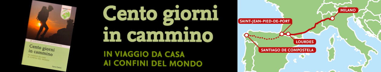
Section 1: from Milan to Montgenevre along the Via Francigena

Starting from Milan towards Pavia, you can follow the path that connects these two cities, running along the Naviglio Pavese. From Pavia on, you can follow the Via Francigena backwards, towards the Montgenevre. For information about the route I bought the “Guida alla Via Francigena” edited by Monica d’Atti and Franco Cinti for Terre di Mezzo (4th edition, April 2012). Updates on accommodation offered to the pilgrims  are constantly made available by the authors at the link http://www.confraternitadisanjacopo.it/Francigena/guida/newsospitalita.htm and I recommend to consult this page before leaving.

However, on the Internet you can find several useful things: first, in the Italian section of the website www.camminando.eu, you can find the updated guides of some Italian routes, among which there is the Via Francigena: Flavio Vandoni, walker and hospitalero, is also happy to provide news and suggestions.

Another useful source is the www.viefrancigene.it website: you can download the list of pilgrim accommodation. Unfortunately, this useful list will guide us only to Vercelli, where the “official” Via Francigena goes up to the Great St. Bernard, but we need to go westward to the Montgenevre.

The Associazione Movimento Lento has also created a group, at this link, inside the Couchsurfing website where pilgrims can ask for hospitality to other members of the community.

Section 2: from the Montgenevre to Arles along the Via Domitia

This section, which long less than 500 km, is the first route that I will walk in French land: it’s an itinerary with a great history and I’m very happy of walking it.

To learn something more, I purchased (on Amazon) the guide “La Via Domitia vers Saint-Jacques-de-Compostelle ou vers Rome” by Jean-Yves Grégoire, published by Rando éditions. It is a small and light book, equipped with maps, route descriptions, historical notes and cultural information on the places to visit. It seems very good, but I will verify it on the ground. The guide does not slavishly follow the GR653D, which is the hiking trail that connects the Montgenevre to Arles: it leaves the trail here and there to meet the cultural (and physical) needs of the pilgrim, who is not always a professional hiker, and tries to trace as far as possible the old Roman route.

If you want to rely on the GR653D all the way, you can buy its Topoguide, published by FFRandonnée. Currently, there are no Italian guides for this route, but you can find some alternative in English.

Here again, the site www.camminando.eu comes to rescue the pilgrim, making available for free download the guides written by Flavio Vandoni, updated annually, reporting maps, a description of the route and the indication of the accommodation for pilgrims.

In France there are some very active and helpful Associations of Friends of the Camino or Friend of St. James: on their websites they often provide the pilgrims with guides and lists of accommodation, which are very useful to those who decide to travel along these routes. This also applies to the Via Domitia. You can find useful information for the whole stretch from Montgenevre to Arles here:  http://www.compostelle-paca-corse.info/. In the section “Hébergements”, you can download the list of pilgrim accommodation and of the responsible of the single regions. The site shows the date of the update of the published information.

Section 3: From Arles to Saint-Jean-Pied-de-Port

For this stretch of way, I will follow the Voie du Piémont Pyrénéen. Who wish to follow the Via Tolosana, they can refer to the guide “Miam Miam Dodo Saint Jacques de Compostelle, La Voie d’Arles/Camino Aragonés GR653” by Mireille Retail, published by Les Éditions du Vieux Crayon. taking care to look for some information on the historical and cultural places to visit, since the Miam Miam Dodo are great for the itinerary and the accommodation, but don’t cover the cultural aspects. Currently, there are no guides in Italian for this route.

For what is about the Voie du Piémont Pyrénéen, waiting for the guide of this Camino that is going to be published by Rando Édition, I got all the information I wanted on the Internet. The first reference is, once again, the website www.camminando.euThere, you can find some different guides: one for the route from Arles to Lourdes and than all the choices you can make to rejoin the Camino Francés on the Pyrenees (the Somport Pass along the Camino Aragonés, the Cize Pass to Saint-Jean-Pied-de-Port, the Camino of the Baztan). Thanks to this source, we will also be able to go from Arles to Carcassonne (the only section where there is no really consolidated route).

In this case too, the Associations of the Friends of the Camino are precious: the site we need is  http://vppyr.free.fr/vpp.phpIn the section Partir>Les étapes, you will find a description stage per stage of the route from Narbonne to Roncesvalles. A list of the accommodation is available from the section Partir>Documents. Among the documents, you can also find a carnet du pèlerin  with the maps and simplest and most useful information.

Section 4: from Saint-Jean-Pied-de-Port to Santiago de Compostela, along the Camino Francés and to Fisterra, along the Camino Fisterrano

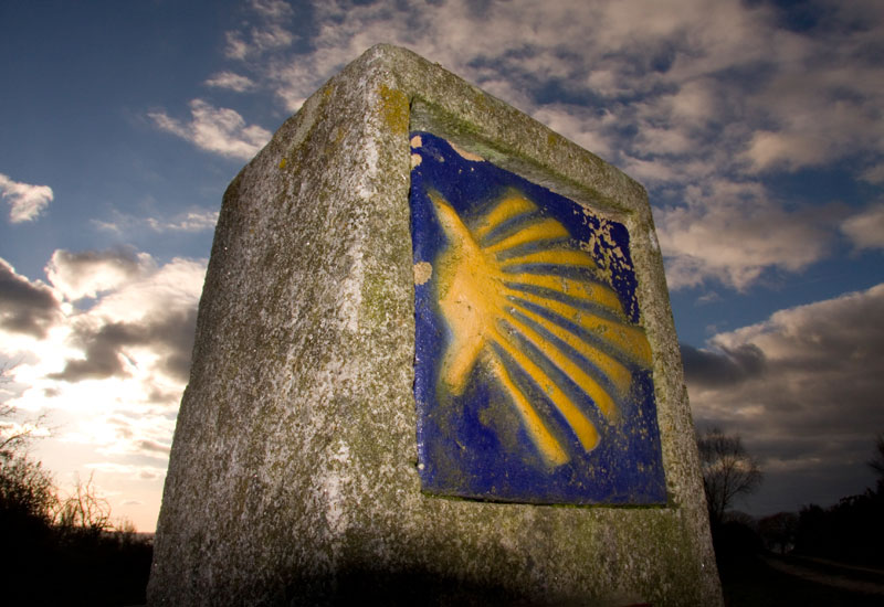
From Saint-Jean-Pied-de-Port starts the “classic” route of the Camino Francés to Santiago de Compostela, you probably will already know it, but you never know… so… just in case: you will find a lot of guide books to this route in all the libraries around the world and you will need them just to know that you have a guide in your backpack and what you want to visit at the end of the daily walk.  It’s impossible to get lost on the French Way (you need to follow the yellow arrows and the blue and yellow shells!). Besides, when you will arrive in Saint-Jean-Pied-de-Port, at the accueil pèlerins, they will provide you the most useful things: a complete list of the albergues with the distances from one to the next one and the elevation profile of the whole Camino.

If you really want to have a paper guide and you are Italian, you can download it in PDF from the site of the PellegriniBelluno. If you are English native speakers, you can download this version always in PDF (it is made available by Greg, a pilgrim like you and me, who committed himself to the translation of the original Spanish guide by Eroski, that you can find here).